We decided to do the walk from the lower car park at Liffey to the top car park and return.
Its about a 9 km hike. The track begins at the campground located downstream on the beautiful Liffey River. The track is very clear as it begins its way north through dry sclerophyll forest with abundant tall, straight trunked gum trees and bracken ferns. A sawmill was located here in bygone times and the timber was all extracted from this valley. There is now little other evidence of forestry activities except for the track itself where felled trees were brought down on a simple log railway. In convict times heavy transport was done by groups of men who were chained together but in the more enlightened times when Liffey was exploited, I suspect horses were used. Animals have been badly treated in the most part. I think back to my own Welsh heritage when my grandfather worked as a boy in the coal mines, sweating beside pit ponies who were born, lived, worked and died without ever seeing the sun.
Thankfully in this part of Tasmania, the forest has been permitted to recover. It lacks the giants of the rainforests seen further south, especially in the magnificent Florentine Valley but there is still plenty of variety to enjoy on this walk.
The sky is hazy from forest fires burning northeast of Launceston. The bluffs above the river are finely obscured by smoke. They are sandstone. It was lifted here by dolerite, which is still deep in the earth, far below our boots. The genesis of the Western Tiers is one of the geological consequences of Antarctica tearing itself from Australia. Antarctica left behind the island of Tasmania with which it has always previously travelled.
The rain and snow spilled onto the high country to the west (well at least West now) and melt water formed torrents, the landform changed, creating the ancestral Liffey River. It flowed with vigour, powered by altitude and abundant water, etching its way through the sandstone. This sandstone forms the river floor and the steep valley sides, littered with caves.
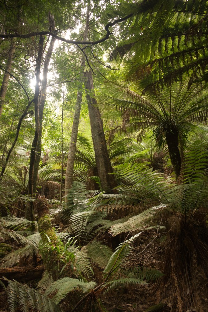
Man ferns, also called Tree ferns, and even more correctly, Dicksonia Antarctica. Again, this link with Antarctica. The track winds gently, swaying and undulating between these tall ferns. They are abundant, especially in dense groves nestled between the larger eucalypts located on the shallower slopes. Their fern branches arch over the track shading walkers like us. The brown fibrous surface of the ferns is inviting to touch, its pleasant to run my fingers over it. The light is even; a sunlight dimmed by morning, smoke, and the many sheltering trees and ferns. It scatters softly over the plants and down along the river; much of the bank is dark, forested, obscured but there are some renegade splashes of light which graze the water or a fortunate fern; aglow before the rest.
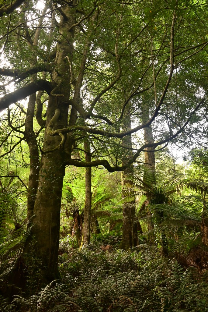
Soon we ascend, into a mixed forest with Myrtle Beech, Dogwood, Native Olives, Leatherwood, Sassafras, Celery top pines and tall eucalypts; the latter stand high, confidently astride the others except for the occasional large Myrtle Beech. The Myrtle Beech is an evergreen with small delicate leaves. Their dropped, brown, dry leaves are scattered over track and forest floor alike.
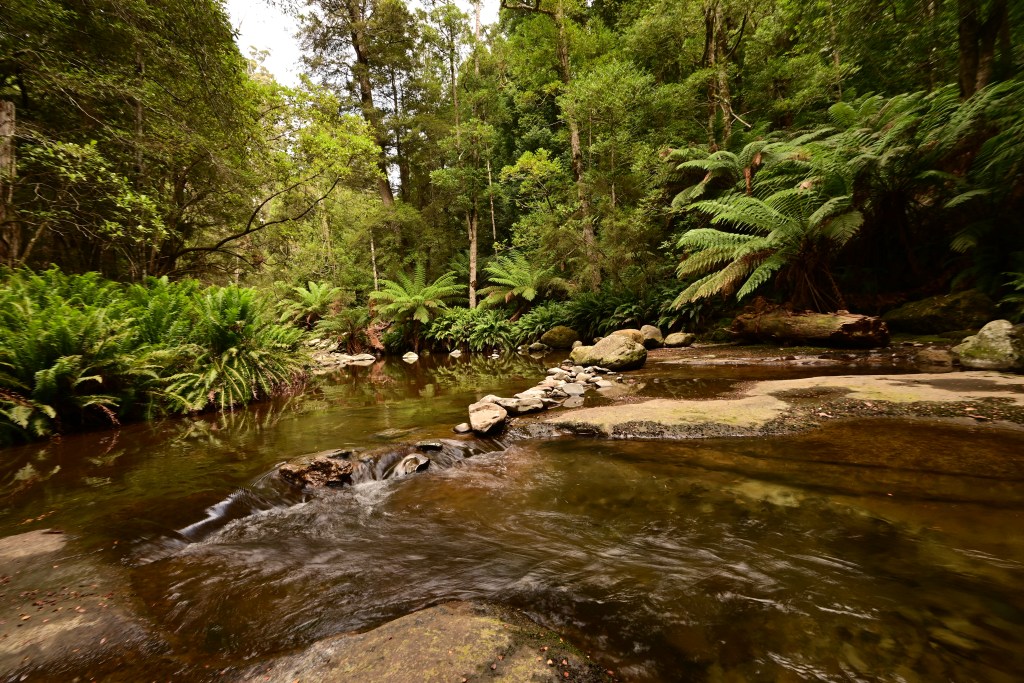
There is always the sound of water flowing, tumbling in the river. At some locations its possible to drop down the bank and look along the stream. It has been unusually dry in Tasmania the last 3 months, and the general water level is low. Fish can be easily seen as they dart to and fro in the transparent water. The ofttimes single river running from bank to bank is now braided into separate, shallow streams; these splash between rocks; at times congregating in deep pools then they continue, their paths re-joining again and again.
We crossed the well fashioned bridge over Quinn’s Creek, a tributary of the Liffey.
A family of Superb Blue Wrens flitted together out of the forest to alight en masse on the branches of tree ferns. They rapidly darted off again and through the twisted branches of Myrtle Beech and as suddenly disappeared as they had arrived.
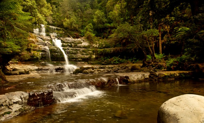
The first waterfall is 4 km from the beginning of the walk. It has been the subject of many calendars including one of mine. There are many round or oval stones that are not sandstone. The question arises about how they got here. They are called drop stones. At one time, probably the last great Ice Age from 2,000, 000 to 10,000 years ago, there were glaciers and ice bergs calved by them. Glaciers collect stones and rocks, then as the Ice bergs begin to melt, these stones are lost and fall to the bottom of the river or lake. The waterfall is series of horizontal sandstone shelves which sweep across the rivers course. It is a delightful waterfall even with the minimal flow we were seeing today.
Jennifer and I set up cameras, attached lenses, played with filters, and took lots of photos. Later we saw a family group with some 2 year and 3-year-olds straddling and climbing the steps to enjoy the views. We carried on the track to the cascades. We sat on a dry rocky platform beside the stream to relax. Afterwards we took more photos of the river, its pools, and cascades as they swirled around us.
We walked up the steps to the car park for a light lunch while sitting at one of the wooden picnic tables. On our return, we stopped off at a look out, then, when I returned to the track, I met a Tiger snake. It was in loose coils sunning on the dusty path. Suddenly unravelled and tried to enter the cover of foliage beside the track. I stepped backwards quickly and inadvertently collided with Jennifer and sent her flying backwards. Jennifer was sore from her heavy landing. Thankfully no permanent damage. The snake was gone by now. Tiger snakes are very venomous. This one was an adolescent as it was not big or long. These are even more risky as they cannot do dry bites very easily or limit the amount of venom they instil into a bite. Tiger snakes can be black (like this one), stripped, or even yellow and have a large head unlike the more delicate tapered head of a Copperhead snake.
It as getting warmer as the morning turned to afternoon. The air was dry and becoming dusty from distant smoke, but the forest was just as beautiful. The harsher light discouraged photography. At the conclusion of the walk, we both felt tired and a little irritable. We had not drunk enough. We knew this as we studied our water bags when we pulled them out of our packs.
Main Liffey FallsAncient Myrtle BeechLiffey River in the early morningdicksonia antartica (tree ferns)upper fallslazy river above the falls
As Jennifer and I are now retired, we have the time to do more walking and not just together each morning on the streets of Launceston but to some of the many beautiful places available to us in Tasmania. Tonight, I am sitting on the big, green couch in our living room. Jennifer is sitting in her favourite chair. She is watching an old episode of New Tricks. I look up occasionally to see what’s happening. I spent an hour or so editing yesterday’s photos. The walk around Lake Dove has been my first opportunity to use the Z5 camera I bought early last year. I took my older Nikon camera and my very portable Lumix on our travels up north.
On Sunday we discussed driving to and exploring Cradle Mountain, well at least Lake Dove. As Jennifer has had some awful injuries over the last few years, any bushwalking must start gently. Tasmania has many wild hikes, and Lake Dove is not one of those. However, in awful weather, even the most benign hike can be dangerous. We have walked Lake Dove in freezing conditions. The track is mostly sheltered from wind and storms, but the surface of the track can freeze over. Snowmelt water pools in the rocky and scree covered paths and then freezes. The track becomes very slippery.
Jennifer decided to buy a roast chicken so she could make up sandwiches the morning of our walk. It has been 4 years since we last walked there , and we were very surprised at the many changes to the facilities and tracks.
We were tardy leaving on Monday morning. I am not clear why merely getting up takes so long when you are retired. Maybe it is the leisurely breakfast, the long shower or basking in the absence of haste. Anyway, we finally set off. It was a magnificent drive when we left the highway. We stopped at ETC for coffees. The road allowed us to cruise beside the Mersey River, we turned before a caravan and car but then were stuck behind a truck. Our reprieve was temporary. The road took us to Moina, nestled in forest, then turned left, past the turn off to Lemonthyme Lodge, then finally to the turn off to Cradle Mountain National Park.
We did not recognise the new visitor centre. A double storey complex with a huge footprint. It does not house many more services than the old, small timber building, but it now looks impressive, and if you feel the need or ever have the opportunity you can swing a cat in it, even a large one. And this you could not do in the old centre. At one end is a shop for souvenirs and some hiking paraphernalia hanging on the display walls, which you should have brought with you before you ever came to Cradle Mountain. At the other end are hermetic reception desks for booking the bus or getting a park pass. We already had our annual pass, so it was the only bus ticket we needed and that’s free. Communication is more difficult as I get older, hearing issues, speed of modern speech, masks and the plastic walls between everybody. I am glad our needs were simple as no complex discussion could begin to take place with any hope of achieving clarity of meaning. None of the Chinese tourists had their bus pass as they waited for the shuttle. When the doors opened, they marched on and just as quickly marched off as the driver shooed them off to get a ticket at the information centre. I don’t understand why a free service needs a ticket. I suspect that collecting the ticket means you must show or buy a Parks pass. No ticket = maybe no pass. These national parks, and none more so than Cradle Mountain, are huge income generators for Tasmania.
The bus stops at the siding, a short walk form the visitor centre, there is a loud whooshing sound as the bus drops downwards to enhance access. We got in and found two seats near the front and tucked up with our packs. So many other walkers are only clutching a mobile phone as they enter the bus. We take the whole proper equipment thing very seriously. Despite the brilliant sunshine baking the entire surface of northern Tasmania and Cradle Mountain in particular, we had water and rain jackets, snake bit kits, in case there were multiple snake bites, extra warm gear, lotions for sunburn and insects as well as the lunches Jennifer had made. The indigenous insects I hate most are March flies. They take not the slightest notice of any insect repellent, whether this is chemical indifference or just plain bloody mindedness, I don’t know. As we have made the effort to put on these revolting sprays, I don’t believe it is unreasonable for any reasonable insect to at least pretend to be repelled by them. Its seems unfair, and even discourteous.
It did not take long to get to Dove Lake. At present, there is no car park as construction work spreads from the building site itself to the old car parking area where all the raw supplies are scattered about. The building is proceeding apace, its wall of glass spanning one entire aspect. The glass reflects the green of the grasses and shrubs. Despites its large size, the building is surprisingly discrete. Now it is not finished and horror of horrors they may give the building a golden roof or add statues of heroic Tasmanian Politicians, both of them.
We walked from the sign in office down a gravel to the track around Lake Dove. We went clockwise as usual. The track is well maintained, the steps graded, though Jennifer does find that the levels of each step are too big for one pace and too small for two. She must do a series of bunny hops to my leisurely amble. At least the steps are not so high that she to climb up or down each one as she had to when descending Tongariro in NZ.
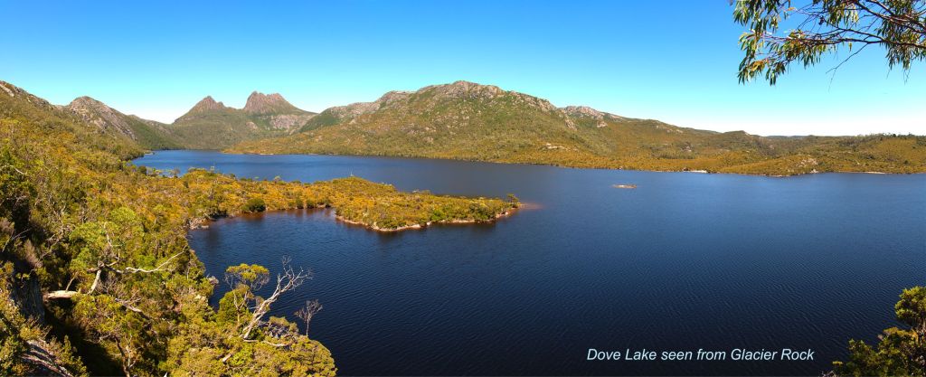
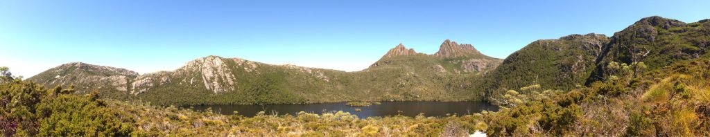
The sky is amazing, I have never experienced this clarity of view and such perfect blue skies. The beauty of the rocks, mountains, towers, water, and plants are for once supplanted by this wonderful light. Everything was lit up. The colours of flowers left over from Spring and summer glittered, the wind propped waves shone over the deep, in stately dance over the lake from edge to edge. Cradle Mountain, Mount Campbell, majestic Hanson Peak, the ruggedly beautiful hanging valley beneath Kathleens Pool, and Marions Peak could be seen in detail, every shadow, every rock and pitted wall, seemed so close, you could reach a hand and drape a finger down along the columns and ancient stone. Distance seemed irrelevant, light connected and illuminated with a rare pleasure.
We stopped at Glacier Rock. I am going to pause here to explains that this feature was once called Suicide rock because of a steep wall and drop to water on one side. This steep wall is very characteristic of glacial action. The glacier met this dense lump of quartzite, and climbed one side, then descended grinding and sculpting the rock. Yet, it proved too tough a beast to be ground out altogether, but the shards it carried all splattered beneath its icy belly, debris it had gathered on its journey from the top of Cradle Mountain, did their damage creating the sheer wall that drops to the lake below me. It is now called Glacier Rock. The top of the rock is now festooned with a wooden veranda, and a rim of steel posts. No more having picnics and seeing your thermos or a younger sibling roll off into the lake. I used to enjoy the clamber on to the top of Glacier rock. In retrospect it was inevitable that anything this close to a road was gong to be made SAFE. I am thankful that the steel posts are dark green and arguably discrete when observed from the other side of the lake. It could have been so much worse.
We carried on our walk, warm in the sunshine and easy underfoot. We stopped frequently to enjoy the views of the trees, shrubs and we even saw an echidna. Another walker stopped on the path, and it was he who silently pointed into the shrubs. There was the echidna, he was resting for only a moment, before he clambered over a branch, gave us a quick, blurry look, then disappeared.
We visited two spits of land, that create small beaches, to look out over the lake. There are fine views to be had and especially of Cradle Mountain. Now the name “Cradle” Mountain has created some confusion over the years, so I have done some research. I used a book and not Google. A practice I no longer thought possible. Well retirement is an opportunity for exploring new ways of being and doing things. Any way. The name cradle precedes the introduction to Australia of the Miners Cradle. It was used to exploit alluvial gold in Victoria and NSW. It was used by surveyors in the 1820’s which is 30 years before the Gold Rush. In fact, It was named after a baby’s cradle, a nineteenth century version at that. It is no wonder that modern parents who can only recall an Ikea inspired bassinet won’t recognize a rocky version of its wooden ancestor. Only compounding the problem of interpretation are the liberal servings of imagination and alcohol, that seem to be fundamental in the naming of features geographic.
One of the great pleasures of walking around this lake is the diversity of plants. Certain aspects lend themselves to certain species. The most sheltered areas favour the beeches, while the darker, cooler spots have pandani reaching upwards in the speckled light. There are waratahs, mountain pepper, celery top pines and many more. At least the celery top pine has leaves that look like celery. It gives one a fighting chance of identifying at least one plant when the flowers have fallen off onto the ground litter. Mountain plum pines with their bright red cherries are plentiful. Cabbage gums, also called Snow gums in Victoria are twisted into agonised contortions by the weather and snow of the cold winter months. Banksia flowers, warm, yellow bottles are splashed atop their trees. The only reliable flower in this location.
We stopped for lunch at our usual spot, a wooden platform nestled at the southern waters of the lake, a spot planted beneath Weinfdorfers Tower. We relaxed, looked around us, chatted, and then ate our sandwiches. Soon after we had finished, one of our daughter’s friends from school with her Mum arrived. It was great to catch up on what Issie had been doing since school. Of course, she keeps reasonably up to date with everyone on Facebook, so we did not have a lot of news for her. They soon left us on the track as we stopped to take more photographs of the forest and lake.
Previously on our visits, the walking from this point on was not as good. This was solely due to these long metal wire paths hanging suspended above the ground. They would wobble as we walked. I never felt safe on them. Now, there is a new surface, rubber matting on firm struts to walk on. This is much more pleasant. The trail goes through beech forest, skirts a rocky prominence then there is an ascent on stairs to the track. This track continues upwards and provides many beautiful views of the mountains. The cliff beneath Kathleen’s pool abuts Marions lookout. This is a massive block of stone; I suspect its quartzite. This would make it much older than the dolerite of which Cradle Mountain, and the towers are made. Quartzite is sandstone which has been heated and compressed by tectonic movement eons ago. Dolerite is magma that erupted form the mantle but is then trapped beneath other layers of rock. the slow cooling that allows giant hexagons to form; the columns that you can see. Quartzite has another property, the tectonic forces that created it, also twisted it and for this reason it is sometimes called Folding rock. there are numerous spots where the grain of the rock can be seen to bend and twist. This all take place long before the dolerite was formed.
The leaves of the Myrtle Beech are all green; no early hints of the colours they will sport in April or May. As we ascended, the forest thinned and stunted, then fell away, till only grasses and low shrubs abutted the track. The track consists of loose stone held by sturdy wooden barriers to each step. The footing was certain for nearly the whole walk. We stopped at the Boathouse by the lake. Its colour, pale and muted greys from its ancient timber slats, blends in with the beach with its grey erratics and the light washed green of the grassed slope behind. On some of the older, less used tracks, the same timber which supplied the wood for the boathouse provided boards; first placed there by Gustav Weindorfer in the 1890s.
We caught the bus back. We were too late for coffees at the café but visited the Souvenir shop before beginning our drive home. As we would not arrive home till after 6 pm, we decided to visit Empire India for dinner. Rogan Josh and Chicken Saagwala are great for dinner after a long but very pleasant hike. When we got home, Jennifer started the washing machine while I passed out. What a super day!
South end of Lake Dove, with Marion’s Peak insightthe boathouse with Cradle Mountain to the left. Glacial Erratics are at the waters edgeFROM LEFT TO RIGHT: Mt Campbell, Hanson’s Peak, Cradle Mountain, and Marion’s Lookout.