Uncategorized

King Solomons cave

On Friday the 18th of March, Jennifer and I drove southwest from our home in Launceston to visit Mole Creek.

We went straight to the ranger station as wanted to purchase tickets for cave tours. Lucky for us there were some afternoon slots still available. It was barely 10am so we had a few hours to kill before our booked lunch at Earthwater Cafe.

We decided to do the short walk to Alum Cliffs lookout which starts the other side of Mole creek. Earlier this morning we had already passed it. Coffee was on the agenda. We stopped at a small cafe, painted blue with a steeply sloping roof. Coffee and Portuguese tarts went down very nicely.

When I was standing by the counter, on the wall behind me, were astronomically themed and framed photographs for sale. Nebulae and galaxies. We bought four of them! They are beautiful images of some of my favorite sights as well as one I have read about but have yet to see; Thors Helmet nebula.

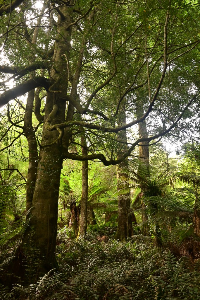
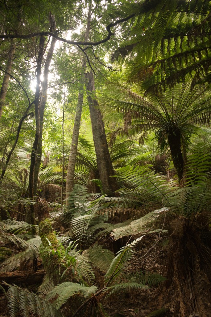
The walk to Alum cliffs lookout begins at the end of a gravel road just before it bends and carries on through farmland. It’s a solid tramp uphill through magnificent and very stately forest. Great, tall eucalypts with a lower storey of bracken and smaller trees including Native Cherries. These were reliable sources of bush food as the trees were covered in delicious red berries between March and December each year.

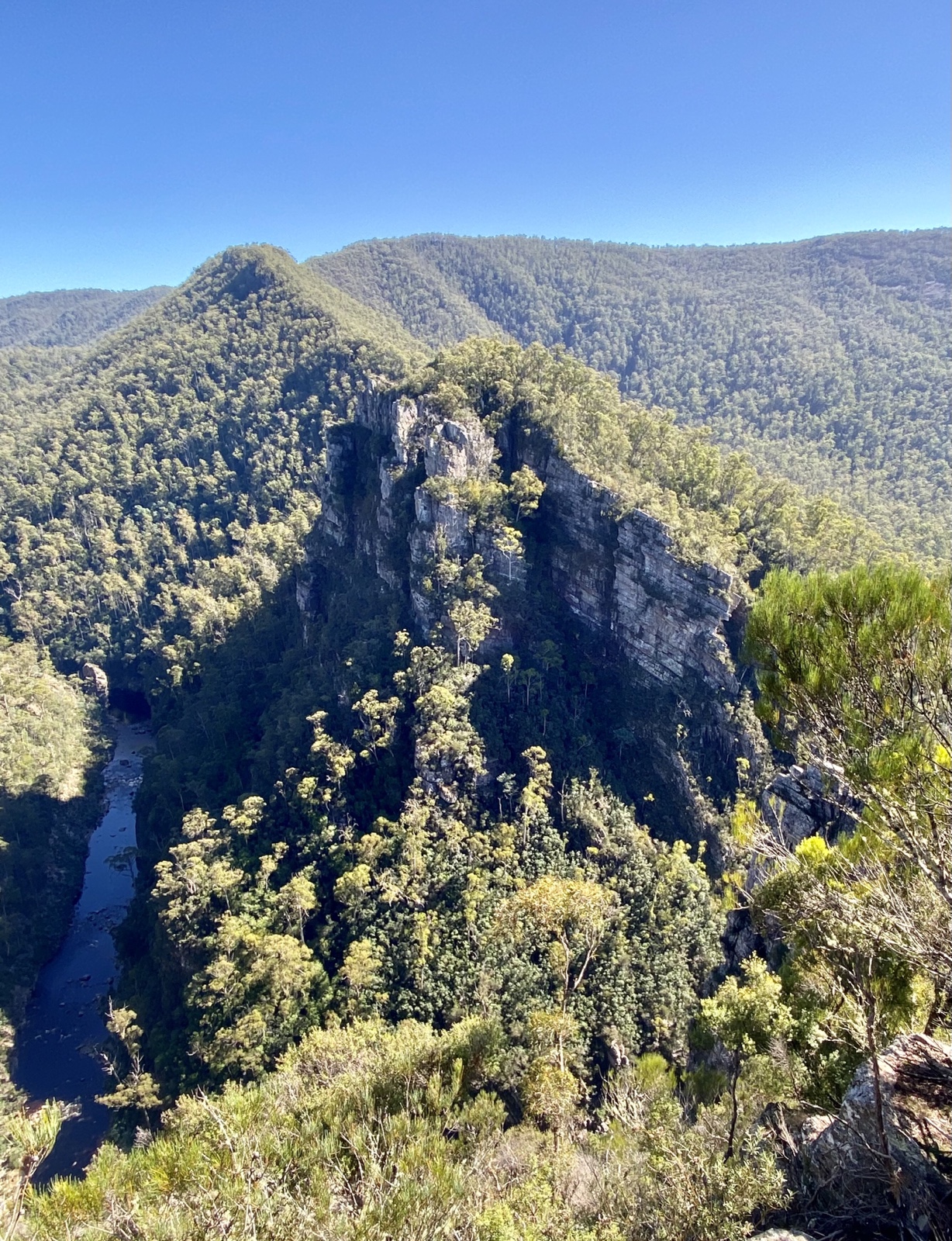
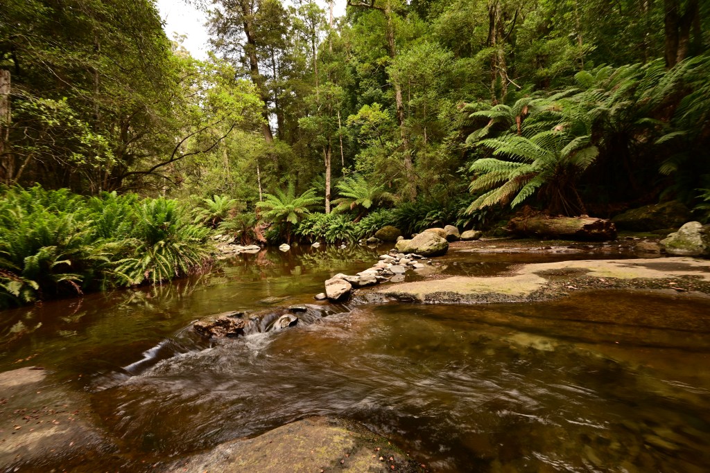
We soon arrived at the lookout. It’s timber framed and ruggedly built, fashioned into two tiers with each providing a different view. The upper tier is positioned to give the best opportunity to see the cliffs while from the lower one you can clearly see the karst towers and ridges high above the river flowing dark and cold.

The alum cliffs are a source of ochre. I could see at least three different colors of clay on the cliff wall. It’s been used by the local Aboriginal people for thousands of years for culture and as the basis for their economy, paying for goods like food, tools and animal skins for clothig from other Aboriginal groups.

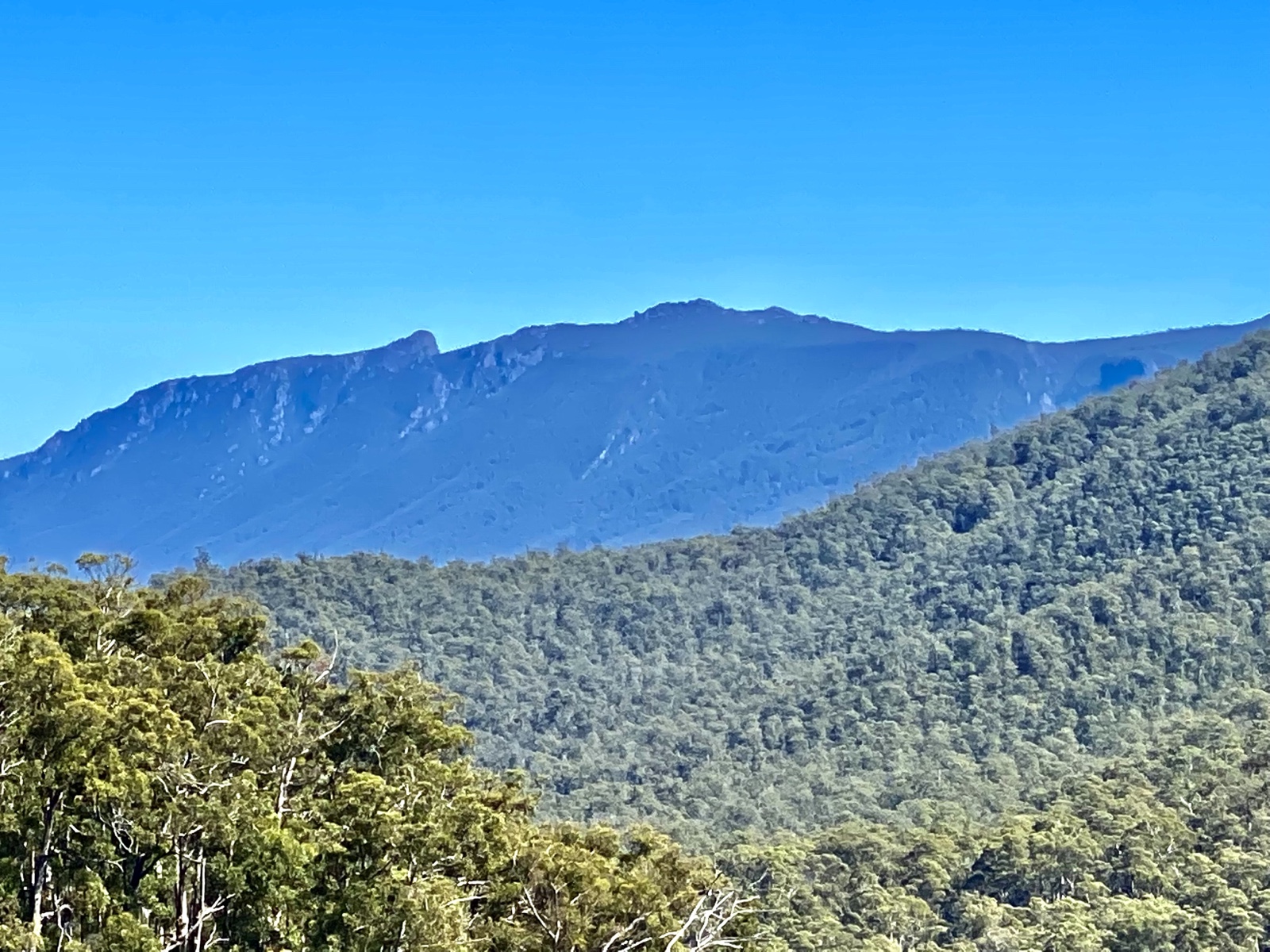
The ridge line to our right drops steeply to a river. Gum trees spot the few locations where the ascending slope pauses for a short horizontal step before recommencing it’s vertical climb. There is A narrow wall of limestone, shear from its base, which ends in a rugged edge of bare stone.

We took many photographs. The blue sky, the isolation, the dramatic scenery was very inspiring for both of us.

We drove back to Earthwater cafe for lunch. We both had vegetable burgers and then shared a chocolate brownie for desert. A wonderful lunch in a picturesque location and beside a spacious garden.

We arrived at King Solomon’s cave an hour early so Jennifer read while I angled my seat back and closed my eyes.

There is a short, shady walk beneath ferns to the waiting area booth. It’s wasn’t long before John, our guide, introduced himself. Due to COVID, the guest numbers are STRICTLY limited to eight people. These small numbers mean it is easy to both hear the guides and take excellent photographs.

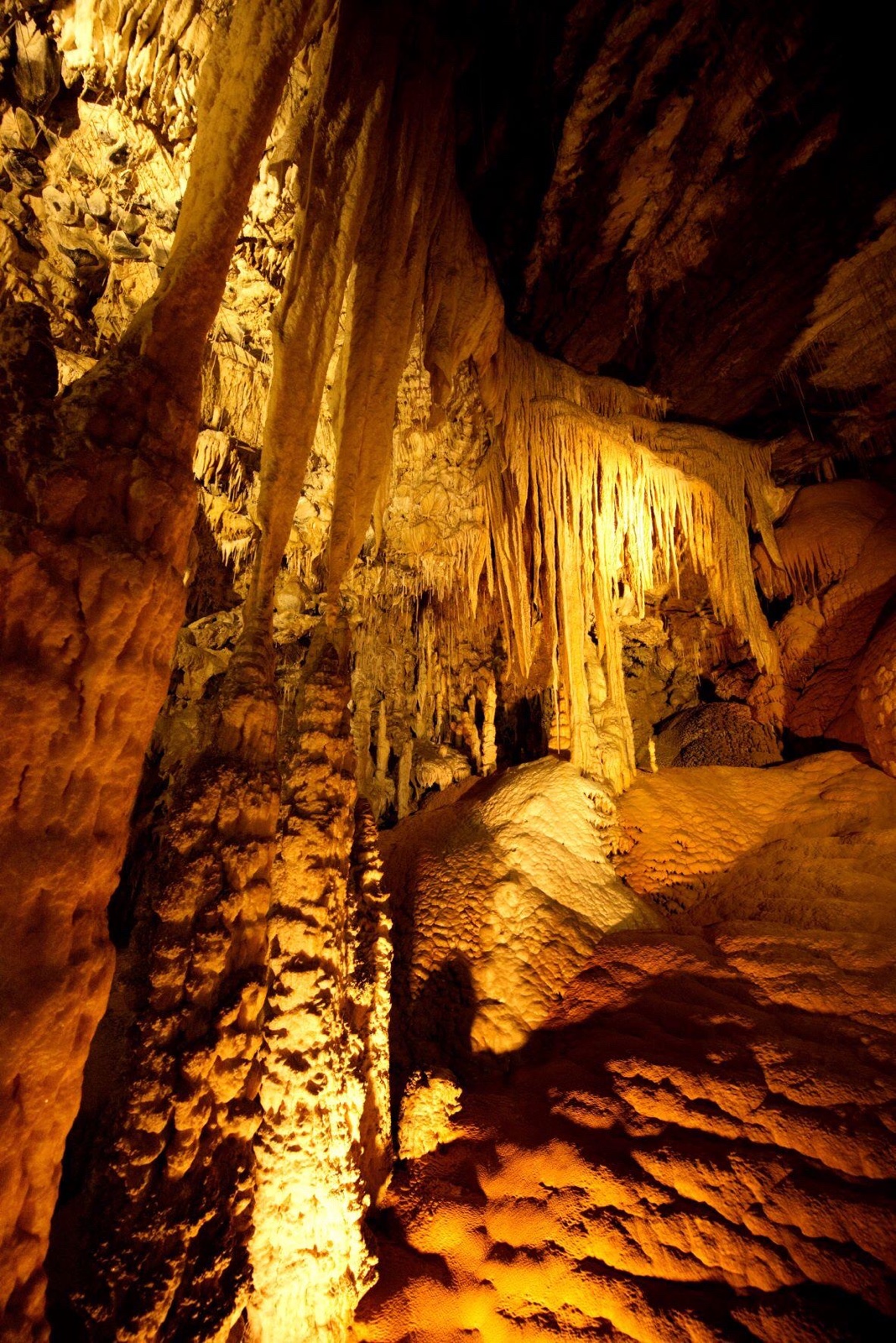
King Solomon’s cave is one of many in the area. It’s limestone country, Karst is the name used by geologists to describe the topography which results from abundant limestone exposed to water. Limestone is finely crushed shells of ancient, tint marine animals. It’s mostly calcium carbonate. There are inevitably joints or cracks in the rock due to pressures from geological forces. In limestone they run in a Criss cross pattern and vertically down at right angles to the surface. These joints permit water to drop down into the limestone and percolate through. They can form rivers, caverns like King Solomon’s cave or tunnels. Rainwater absorbs carbon dioxide, which converts neutral water with no capacity to dissolve limestone into a solution of carbonic acid which can. Each drop of calcium carbonate laden water, a load collected in its passage through the limestone above the cave, hangs suspended high above us. The water loses its carbon dioxide to the air in the cave and the calcium carbonate comes out of solution contributing to one of many different speleothems. This is the general term for the many fascinating manifestations of crystallizing calcium carbonate, this crystal is also called calcite.

Calcite can be pure white, it can be stained orange by iron oxide, grey by contamination with tin, or uncommonly it can have pink tint from manganese. There can be flowstone. There is a massive flow stone in Marakoopa cave which hovers above the river located there. There are straws. These are long, hollow and impossibly delicate structures which hang downwards up to 6 meters from the ceiling. Water dribbles through the straw, and deposits a minuscule layer of calcite at the tip of the slowly growing straw, before dropping to the floor. When some debris blocks the straw, water escapes and flows down the outside and in time, in thousands of years. A stalactite will form. There are variations such as “parsnips” and “Turnips” which are small but peculiar looking excrescences held suspended by a straw.

While the stalactite always has a hollow straw in its heart, a stalagmite is the splash point and forms a round dome. As time passes, the two structures, the stalactite above and the stalagmite below, may join and flow together creating a column.

The precipitation of calcite can form sculptures which the guides are keen to point out, the three cats, the little mermaid riding a dolphin and so on. I think the science and beauty of this environment is considerable and does not need the razzamatazz of conjuring patterns in clouds.

There are shawls also called bacon rinds , which form from water trickling to and fro but ultimately downwards, creating a waving and translucent sheet of calcite. There can be many of these on the walls or dangling from prominences in the cave. Stalactites can crowd the ceiling creating a veritable organ loft of orange stone.

There are tiny grottos lit by lights tucked in a corner, out of sight.

We followed along behind our guide. John frequently stopped to explain and draw our attention to the fascinating features that crowded around us. The illumination provided by installed lights is a good white balance, with a good rendition of the actual colors as you see them in daylight.

After our wonderful walk through a portion of the cave we quickly drove to Marakoopa cave. We were there in plenty of time to meet our guide, this time a woman called Sue escorted us. Like John, Sue was friendly and also very knowledgeable about the caves.

For the first thirty meters, no one is permitted to take photographs as the light from the cameras disturbs the flow worms on the cave ceiling. Even with the flash off, many cameras use light to help with focusing in dark conditions and these are dark conditions

Later in our visit, Sue turned the artificial illumination off. The darkness is TOTAL. Eyes are utterly useless, there is nothing in front of them. To be in such complete night is unnerving. Even night is a poor comparison to cave or mine darkness as the moon or stars usually give some light, and if the eyes have long enough, you can pick out something but now, in this cave, darkness blanketed each of us.

The insects here as well as other invertebrates have all lost both the power of sight and of any pigments that rely on sight to provide any survival advantage. You don’t need camouflage in the dark. Cave spiders can live for thirty years and can reach 20 cm in breadth. Their legs are unusually long. Their lungs are on the outside of their abdomens. We saw not only the shed carapace and limbs of a spider but saw two specimens. A youngster and an older bigger one, the latter nestled in a rock cleft with her web spanning an aerial thoroughfare. We saw a cave cricket. Again it had unusually long legs. I wonder if this is an adaption to help proprioception of its world, much as blind people benefit from a white stick. There are blind shrimp in the underground stream, creatures that will never leave the dark confines of this cave.

Both caves are very beautiful, King Solomon’s cave with its jeweled and richly decorated caverns and Marakoopa with its underground river and cool, still pools suspended in calcite ponds and behind frozen waterfalls of creamy drip stone.

Standard
Uncategorized

Speelers Track

6/3/22

On Sunday the 6.3.22 I joined seven other Ramblers for a trip to Speelers plain. I woke up early on Sunday morning with the sound of wind buffeting the trees and our windows. We checked the weather and though Launceston was going to experience strong winds for most of the day, the prediction for Cradle Mountain was excellent, and so it proved to be. Jennifer opted out because of concerns about tree roots which can be ankle twisting if wet and slippery. In retrospect She would have been fine but it’s best to be safe.

I drove my Honda to the Ranger station opposite the mountain lodge. I had a passenger as well. As I have mentioned, there were eight of us.

After assembling and kitting up in the car park, we set off along Pencil Pine creek on the Enchanted walk. All of this was in brilliant sunshine. A metre long Tiger snake was basking on a rock beside the walking track. 

The track is very benign here, beginning on boardwalk. It continues along the banks of the creek winding beneath myrtle beech and other rainforest trees and shrubs. It skirts button grass meadows dotted with a few tall eucalypts. We took the turn off to the pond behind Cradle mountain lodge and passing that we followed the signs to Speelers track.

The track has some elevation and descents to negotiate but they are not difficult, not technically demanding at all. We walked past a creek then entered thicker, taller forest.

We soon reached extensive button grass plains. There was some water to be seen but it wasn’t much compared to many other walks in Tasmania. Myrtle beech, groves of early flowering celery top pine, it’s small white flowers emerging from buds, sassafras and groups of tall eucalypts. Later we saw massive, old King Billy pines on the King Billy Track. This track joins the Speelers track toward the end.

There were tree roots but as the slope was minimal and the wood mostly dry, they were not a problem walking. 

The plains called Speelers Plain is a large area of button grass, with clumps of xanthorrhea on its perimeter. I could imagine this place being very cold in  any strong wind or heavy rain. Today was great, unlimited sunshine with only a mild breeze. I wore a light top for the walk but many of the walkers were comfortable in  shirts.

The track had no other walkers until near the end. The many natural scenes we encountered provided wonderful vignettes. Each a seperate image which includes sounds and smells.As we began our gentle descent and before we re entered the forest, here was a panorama;  of trees, plains, and with crystal clear views of Barn Bluff and Cradle Mountain in the distance. 

We stopped to take many photos and admire the many fungi. They were of different colours, shapes and sizes. On  dead logs or sheltered on the cool wet bark of trees. They liked shadows but some were in bright sunshine surrounded by King Billy fronds, beech leaves and rampant mosses. 

The myrtle beech varied as well from scraggy shrubs to dense, majestic forest. Thick mosses covered Spring fallen limbs and trunks of trees,  creating a rolling, repeating, chaotic sea of green as I peered into the forest in any direction from where I stopped.

It is very peaceful in the cool of the forest or walking beside the button grass. There is no need to rush, no need to think about all todays worries of the world. It’s a joy to have some space between the concerns of every day.

We stopped for lunch overlooking the plains. The sky was blue and clear; no haze hovered over the forests and mountains behind us. Distances seemed hardly to exist at all.

Pencil Pine Falls

Mountain rockey
Speelers Plain
Cradle
Tiger snake
Standard
Hiking, tasmania

Liffey Falls walk, Northern Tasmania

14.2.2022

We decided to do the walk from the lower car park at Liffey to the top car park and return.

Its about a 9 km hike. The track begins at the campground located downstream on the beautiful Liffey River. The track is very clear as it begins its way north through dry sclerophyll forest with abundant tall, straight trunked gum trees and bracken ferns. A sawmill was located here in bygone times and the timber was all extracted from this valley. There is now little other evidence of forestry activities except for the track itself where felled trees were brought down on a simple log railway. In convict times heavy transport was done by groups of men who were chained together but in the more enlightened times when Liffey was exploited, I suspect horses were used.  Animals have been badly treated in the most part. I think back to my own Welsh heritage when my grandfather worked as a  boy in the coal mines, sweating beside pit ponies who were born, lived, worked and died without ever seeing the sun.

Thankfully in this part of Tasmania, the forest has been permitted to recover. It lacks the giants of the rainforests seen further south, especially in the magnificent Florentine Valley but there is still plenty of variety to enjoy on this walk.

The sky is hazy from forest fires burning northeast of Launceston. The bluffs above the river are finely obscured by smoke. They are sandstone. It was lifted here by dolerite, which is still deep in the earth, far below our boots. The genesis of the Western Tiers is one of the geological consequences of Antarctica tearing itself from Australia. Antarctica  left behind the island of Tasmania with which it has always previously travelled.

The rain and snow spilled onto the high country to the west (well at least West now) and melt water formed torrents, the landform changed, creating the ancestral Liffey River. It flowed with vigour, powered by altitude and abundant water, etching its way through the sandstone. This sandstone forms the river floor and the steep valley sides, littered with caves.

Man ferns, also called Tree ferns, and even more correctly, Dicksonia Antarctica. Again, this link with Antarctica. The track winds gently, swaying and undulating between these tall ferns. They are abundant, especially in dense groves nestled between the larger eucalypts located on the shallower slopes. Their fern branches arch over the track shading walkers like us. The brown fibrous surface of the ferns is inviting to touch, its pleasant to run my fingers over it. The light is even; a sunlight dimmed by morning, smoke, and the many sheltering trees and ferns. It scatters softly over the plants and down along the river; much of the bank is dark, forested, obscured but there are some renegade splashes of light which graze the water or a fortunate fern; aglow before the rest.

Soon we ascend, into a mixed forest with Myrtle Beech, Dogwood, Native Olives, Leatherwood, Sassafras, Celery top pines and tall eucalypts; the latter stand high, confidently astride the others except for the occasional large Myrtle Beech. The Myrtle Beech is an evergreen with small delicate leaves. Their dropped, brown, dry leaves are scattered over track and forest floor alike.

There is always the sound of water flowing, tumbling in the river. At some locations its possible to drop down the bank and look along the stream. It has been unusually dry in Tasmania the last 3 months, and the general water level is low. Fish can be easily seen as they dart to and fro in the transparent water.  The ofttimes single river running from bank to bank is now braided into separate, shallow streams; these splash between rocks; at times congregating in deep pools then they continue, their paths re-joining again and again.

We crossed the well fashioned bridge over Quinn’s Creek, a tributary of the Liffey.

A family of Superb Blue Wrens flitted together out of the forest to alight en masse on the branches of tree ferns. They rapidly darted off again and through the twisted branches of Myrtle Beech and as suddenly disappeared as they had arrived.

The first waterfall is 4 km from the beginning of the walk. It has been the subject of many calendars including one of mine. There are many round or oval stones that are not sandstone. The question arises about how they got here. They are called drop stones. At one time, probably the last great Ice Age from 2,000, 000 to 10,000 years ago, there were glaciers and ice bergs calved by them. Glaciers collect stones and rocks, then as the Ice bergs begin to melt, these stones are lost and fall to the bottom of the river or lake. The waterfall is series of horizontal sandstone shelves which sweep across the rivers course. It is a delightful waterfall even with the minimal flow we were seeing today.

Jennifer and I set up cameras, attached lenses, played with filters, and took lots of photos. Later we saw a family group with some 2 year and 3-year-olds straddling and climbing the steps to enjoy the views. We carried on the track to the cascades. We sat on a dry rocky platform beside the stream to relax. Afterwards we took more photos of the river, its pools, and cascades as they swirled around us.

We walked up the steps to the car park for a light lunch while sitting at one of the wooden picnic tables. On our return, we stopped off at a look out, then, when I returned to the track, I met a Tiger snake. It was in loose coils sunning on the dusty path. Suddenly unravelled and tried to enter the cover of foliage beside the track. I stepped backwards quickly and inadvertently collided with Jennifer and sent her flying backwards. Jennifer was sore from her heavy landing. Thankfully no permanent damage. The snake was gone by now. Tiger snakes are very venomous. This one was an adolescent as it was not big or long. These are even more risky as they cannot do dry bites very easily or limit the amount of venom they instil into a bite. Tiger snakes can be black (like this one), stripped, or even yellow and have a large head unlike the more delicate tapered head of a Copperhead snake.

It as getting warmer as the morning turned to afternoon. The air was dry and becoming dusty from distant smoke, but the forest was just as beautiful. The harsher light discouraged photography. At the conclusion of the walk, we both felt tired and a little irritable. We had not drunk enough. We knew this as we studied our water bags when we pulled  them out of our packs.

Main Liffey Falls
Ancient Myrtle Beech
Liffey River in the early morning
dicksonia antartica (tree ferns)
upper falls
lazy river above the falls
Standard